
Garmin Bluechart G2 HXUS029R - Southern Bahamas microSD/SD - 010-C0730-20
Pagamento em prestações
- Primeira prestação a pagar hoje54,46€
- a 25/05/202454,43€
- a 24/06/202454,43€
- a 24/07/202454,43€
Destaques


Garmin HXUS029R G3 Micro SD Souther Bahamas - GAR010C073020
Pagamento em prestações
- Primeira prestação a pagar hoje54,46€
- a 25/05/202454,43€
- a 24/06/202454,43€
- a 24/07/202454,43€
Todas as Ofertas (2)
Garmin HXUS029R G3 Micro SD Souther Bahamas - GAR010C073020
Pagamento em prestações
- Primeira prestação a pagar hoje54,46€
- a 25/05/202454,43€
- a 24/06/202454,43€
- a 24/07/202454,43€

Garmin BlueChart g3 HXUS029R - Southern Bahamas - 010-C0730-20
Detalhes do Produto
$200 Cash Back w/Qualifying Purchases UNTIL 07/07/2019 VIEW
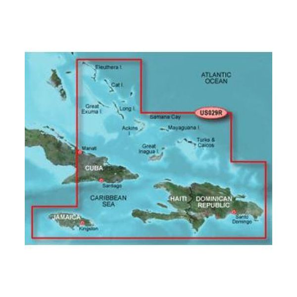
BlueChart® g3 HD - HXUS029R - Southern Bahamas - microSD™/SD™
Coverage:
Featuring data from Explorer Charts for the Bahamas. Detailed coverage from Eleuthera Island, Bahamas to the Dominican Republic, including the Bahamian islands of Great Exuma, Great Inagua, Mayaguana, and many others. Also includes detailed coverage of the Jamaican, Haitian, and Dominican coasts in their entirety, the easternmost quarter of Cuba, and the Turks and Caicos Islands.
Unparalleled Coastal Chart Coverage
- Provides industry-leading coverage, clarity and detail with updated coastal charts that feature integrated Garmin and Navionics® data
- Auto Guidance¹ technology calculates a route using your desired depth and overhead clearance and provides a suggested path to follow
- Includes Depth Range Shading for up to 10 depth ranges, enabling you to view your target depth at a glance
- Up to 1’ contours provide a more accurate depiction of the bottom structure for improved fishing charts and navigation in swamps, canals and marinas
- NOAA raster cartography² is available as a free downloadable feature via the ActiveCaptain® app
BlueChart g3 coastal charts provide industry-leading coverage, clarity and detail with integrated Garmin and Navionics data. Also included is Auto Guidance¹ technology, which uses your desired depth and overhead clearance to calculate routes and provide a suggested path to follow — overlaid onto your chart. NOAA raster cartography is also available as a free downloadable feature via the ActiveCaptain app. It gives your chartplotter paper chartlike views of NOAA-surveyed areas in which individual points of interest are labeled with corresponding longitude and latitude information. Worldwide coverage is available by regions as accessory cards or via download; each region is sold separately.
Auto Guidance Technology
The Auto Guidance feature¹ calculates a suggested route using your desired depth and overhead clearance.
Depth Range Shading
This feature displays high-resolution Depth Range Shading for up to 10 depth ranges so you can view your designated target depth.
Detailed Contours
BlueChart g3 features up to 1’ contours, which provide a more accurate depiction of the bottom structure for improved fishing charts and navigation in swamps, canals and marinas.
Shallow Water Shading
To aid in navigation, Shallow Water Shading allows map shading at a user-defined depth to give a clear picture of shallow waters to avoid.
NOAA Raster Cartography
This feature gives your chartplotter paper chartlike views of NOAA-surveyed areas in which points of interest are labeled with corresponding longitude and latitude information.
¹Auto Guidance is for planning purposes only and does not replace safe navigation operations
²Raster cartography cannot be viewed on echoMAP CHIRP and ECHOMAP Plus combos but can be viewed on mobile devices via the ActiveCaptain mobile app .
WARNING: This product can expose you to chemicals which are known to the State of California to cause cancer, birth defects or other reproductive harm. For more information go to P65Warnings.ca.gov.
Owner\'s Manual (pdf)
Características
Características
- Cobertura geográficaSouthern Bahamas
- TipologiaMapa rodoviário
- ModeloAlpha® Astro® Colorado® 300 Colorado® 400c Colorado® 400i Colorado® 400t Dakota® 20 echoMAP™ 43dv echoMAP™ 44dv echoMAP™ 50dv echoMAP™ 50s echoMAP™ 53dv echoMAP™ 54dv echoMAP™ 70dv echoMAP™ 70s echoMAP™ 73dv echoMAP™ 73sv echoMAP™ 74dv echoMAP™ 74sv echoMAP™ 93sv echoMAP™ 94sv epix™ eTrex Legend® HCx eTrex Vista® HCx eTrex® 20 eTrex® 20x eTrex® 30 eTrex® 30x eTrex® Touch 25 eTrex® Touch 35 eTrex® Touch 35t GPSMAP® 1040xs GPSMAP® 2106 GPSMAP® 2110 GPSMAP® 2206 GPSMAP® 2210 GPSMAP® 396 GPSMAP® 4008 GPSMAP® 4010 GPSMAP® 4012 GPSMAP® 420/420s GPSMAP® 4208 GPSMAP® 421 GPSMAP® 4210 GPSMAP® 4212 GPSMAP® 421s GPSMAP® 430/430s GPSMAP® 431 GPSMAP® 431s GPSMAP® 440/440s GPSMAP® 441 GPSMAP® 441s GPSMAP® 495 GPSMAP® 5008 GPSMAP® 5012 GPSMAP® 5015 GPSMAP® 520/520s GPSMAP® 5208 GPSMAP® 521 GPSMAP® 5212 GPSMAP® 5215 GPSMAP® 521s GPSMAP® 525/525s GPSMAP® 526 GPSMAP® 526s GPSMAP® 530/530s GPSMAP® 531 GPSMAP® 531s GPSMAP® 535/535s GPSMAP® 536 GPSMAP® 536s GPSMAP® 540/540s GPSMAP® 541 GPSMAP® 541s GPSMAP® 545/545s GPSMAP® 546 GPSMAP® 546s GPSMAP® 547 GPSMAP® 547xs GPSMAP® 60CSx GPSMAP® 60Cx GPSMAP® 62 GPSMAP® 6208 GPSMAP® 6212 GPSMAP® 62s GPSMAP® 62sc GPSMAP® 62stc GPSMAP® 64 GPSMAP® 640 GPSMAP® 64s GPSMAP® 64st GPSMAP® 720 GPSMAP® 720s GPSMAP® 7212 GPSMAP® 7215 GPSMAP® 740 GPSMAP® 740s GPSMAP® 741 GPSMAP® 741xs GPSMAP® 7607 GPSMAP® 7607xsv GPSMAP® 7608 GPSMAP® 7608xsv GPSMAP® 7610 GPSMAP® 7610xsv GPSMAP® 7612 GPSMAP® 7612xsv GPSMAP® 7616 GPSMAP® 7616xsv GPSMAP® 76CSx GPSMAP® 76Cx GPSMAP® 78 GPSMAP® 78s GPSMAP® 78sc GPSMAP® 8208 MFD GPSMAP® 8212 MFD GPSMAP® 8215 MFD GPSMAP® 840xs GPSMAP® 8500 Black Box GPSMAP® 8530 Black Box Montana® 600 Montana® 600t Camo Montana® 610 Montana® 610t Camo Montana® 650 Montana® 650t Montana® 680 Montana® 680t Monterra™ nüvi® 500 nüvi® 550 Oregon® 200 Oregon® 300 Oregon® 400c Oregon® 400i Oregon® 400t Oregon® 450 Oregon® 450t Oregon® 550 Oregon® 550t Oregon® 600 Oregon® 600t Oregon® 650 Oregon® 650t Rino® 520HCx Rino® 530HCx Rino® 650 Rino® 650t Rino® 655t Volvo Penta Glass Cockpit System