


Garmin Bluechart G2 HXCA015R - Canada g2 microSD/SD - 010-C1019-20
Pagamento em prestações
- Primeira prestação a pagar hoje77,41€
- a 20/05/202477,41€
- a 19/06/202477,41€
- a 19/07/202477,41€
Destaques


Garmin HXCA600X G3 Micro SD Canada - GAR010C101920
Pagamento em prestações
- Primeira prestação a pagar hoje77,41€
- a 20/05/202477,41€
- a 19/06/202477,41€
- a 19/07/202477,41€
Todas as Ofertas (1)
Garmin HXCA600X G3 Micro SD Canada - GAR010C101920
Pagamento em prestações
- Primeira prestação a pagar hoje77,41€
- a 20/05/202477,41€
- a 19/06/202477,41€
- a 19/07/202477,41€
Detalhes do Produto
$200 Cash Back w/Qualifying Purchases UNTIL 07/07/2019 VIEW
BlueChart® g3 HD - HXCA600X - Canada - microSD™/SD™
Coverage:
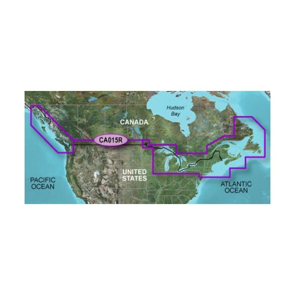
Provides detailed coastal coverage of the North America East Coast from Nain, NL to Raritan Bay, NY featuring Newfoundland, Ile d\'Anticosti, New York Harbor, and full US and Canadian coverage of the Great Lakes in their entirety. The North American West Coast is covered from Glacier Bay, AK to Aberdeen, WA featuring British Columbia, Vancouver, the Queen Charlotte Islands, and Puget Sounds.
Unparalleled Coastal Chart Coverage
- Provides industry-leading coverage, clarity and detail with updated coastal charts that feature integrated Garmin and Navionics® data
- Auto Guidance¹ technology calculates a route using your desired depth and overhead clearance and provides a suggested path to follow
- Includes Depth Range Shading for up to 10 depth ranges, enabling you to view your target depth at a glance
- Up to 1’ contours provide a more accurate depiction of the bottom structure for improved fishing charts and navigation in swamps, canals and marinas
- NOAA raster cartography² is available as a free downloadable feature via the ActiveCaptain® app
BlueChart g3 coastal charts provide industry-leading coverage, clarity and detail with integrated Garmin and Navionics data. Also included is Auto Guidance¹ technology, which uses your desired depth and overhead clearance to calculate routes and provide a suggested path to follow — overlaid onto your chart. NOAA raster cartography is also available as a free downloadable feature via the ActiveCaptain app. It gives your chartplotter paper chartlike views of NOAA-surveyed areas in which individual points of interest are labeled with corresponding longitude and latitude information. Worldwide coverage is available by regions as accessory cards or via download; each region is sold separately.
Auto Guidance Technology
The Auto Guidance feature¹ calculates a suggested route using your desired depth and overhead clearance.
Depth Range Shading
This feature displays high-resolution Depth Range Shading for up to 10 depth ranges so you can view your designated target depth.
Detailed Contours
BlueChart g3 features up to 1’ contours, which provide a more accurate depiction of the bottom structure for improved fishing charts and navigation in swamps, canals and marinas.
Shallow Water Shading
To aid in navigation, Shallow Water Shading allows map shading at a user-defined depth to give a clear picture of shallow waters to avoid.
NOAA Raster Cartography
This feature gives your chartplotter paper chartlike views of NOAA-surveyed areas in which points of interest are labeled with corresponding longitude and latitude information.
¹Auto Guidance is for planning purposes only and does not replace safe navigation operations
²Raster cartography cannot be viewed on echoMAP CHIRP and ECHOMAP Plus combos but can be viewed on mobile devices via the ActiveCaptain mobile app .
WARNING: This product can expose you to chemicals which are known to the State of California to cause cancer, birth defects or other reproductive harm. For more information go to P65Warnings.ca.gov.
Owner\'s Manual (pdf)
Características
Características
- Cobertura geográficaCanada g2
- TipologiaMapa rodoviário
- ModeloDakota® 20 echoMAP™ 42dv echoMAP™ 45dv echoMAP™ 50dv echoMAP™ 50s echoMAP™ 52dv echoMAP™ 55dv echoMAP™ 70dv echoMAP™ 70s echoMAP™ 72sv echoMAP™ 75sv echoMAP™ 92sv echoMAP™ 95sv epix™ eTrex Legend® HCx eTrex Vista® HCx eTrex® 20 eTrex® 20x eTrex® 30 eTrex® 30x eTrex® Touch 25 eTrex® Touch 35 GPSMAP® 1020xs GPSMAP® 2106 GPSMAP® 2110 GPSMAP® 4008 GPSMAP® 4010 GPSMAP® 4012 GPSMAP® 420/420s GPSMAP® 450/450s GPSMAP® 451 GPSMAP® 451s GPSMAP® 495 GPSMAP® 5008 GPSMAP® 5012 GPSMAP® 5015 GPSMAP® 521 GPSMAP® 521s GPSMAP® 527 GPSMAP® 527xs GPSMAP® 550/550s GPSMAP® 551 GPSMAP® 551s GPSMAP® 555/555s GPSMAP® 556 GPSMAP® 556s GPSMAP® 557 GPSMAP® 557xs GPSMAP® 60CSx GPSMAP® 60Cx GPSMAP® 62 GPSMAP® 620 GPSMAP® 62s GPSMAP® 62sc GPSMAP® 62stc GPSMAP® 64 GPSMAP® 64s GPSMAP® 64st GPSMAP® 720 GPSMAP® 721 GPSMAP® 721xs GPSMAP® 7407 GPSMAP® 7407xsv GPSMAP® 7408 GPSMAP® 7408xsv GPSMAP® 7410 GPSMAP® 7410xsv GPSMAP® 7412 GPSMAP® 7412xsv GPSMAP® 7416 GPSMAP® 7416xsv GPSMAP® 750 GPSMAP® 750s GPSMAP® 751 GPSMAP® 751xs GPSMAP® 76CSx GPSMAP® 76Cx GPSMAP® 78 GPSMAP® 78s GPSMAP® 8008 MFD GPSMAP® 8012 MFD GPSMAP® 8015 MFD GPSMAP® 820 GPSMAP® 820xs GPSMAP® 8500 Black Box GPSMAP® 8530 Black Box Montana® 600 Montana® 610 Montana® 650 Montana® 650t Montana® 680 Montana® 680t Monterra™ nüvi® 550 Oregon® 200 Oregon® 300 Oregon® 450 Oregon® 550 Oregon® 550t Oregon® 600 Oregon® 600t Oregon® 650 Oregon® 650t Volvo Penta Glass Cockpit System